On April 19 Emily, Kris and I set off to drive around the country. We took the route as outlined in the picture below, colour-coded for easy viewing :) If you want to see in more detail, you can click on the picture!
Kris's blog (
http://kitiniceland.blogspot.com) has some great stories from the driver's (and terrified passenger...) perspective!
 |
| Our 5-day road trip |
Day one was the green drive, along the southern part of the country. We could cover a lot of ground because we've already seen at lot that this part of the country has to offer (see "South Iceland Roadtrip" in February). We left at 7am, and drove through a few towns before getting to the barren South coast. We drove through Selfoss, which had super snowy roads, and Hella, which had populations of 6,500 and 650, respectively. We got really lucky with weather for the first couple of days, and were graced with sunshine nearly the entire day!
 |
| Mountains in the early morning sun |
 |
| A pipe carrying hot water |
 |
| Early morning sun |
 |
| The snowy main road in Selfoss |
We took a break from driving once we pulled onto road 242, which leads to the ice cap Eyjafjallajökull - which covers the volcano that errupted last year. The entire area is covered in black ash (which, on the day we went, was covered in snow). There is a pool nearby that was closed, but which is full of ash still. There was a raised line along the base of the volcano which covered a pipe that was exposed in areas.
Kris climbed up the scree - a new word for me! A scree is the rock and debris at the bottom of a mountain. Iceland is especially known for having large screes by most of its larger mountains. The high winds in Iceland drive rain into the holes and cracks in the sides of the mountain. Since the temperature fluctuates so much here, the water then often freezes, breaking small pieces off. These small pieces fall and gather at the base of the mountains.
 |
| Eyjafjallajökull mountain |
 |
| A house by Eyjafjallajökull |
 |
| The snow-covered ash |
 |
| Kris climbing up the scree |
 |
| Loads of ash! |
 |
| Emily and I on an exposed part of the pipe |
 |
| Running by Eyjafjallajökull |
 |
| The old pool |
One thing I've noticed but haven't managed to take a decent picture of yet is the way people living beside a mountain protect their homes. Falling snow can be a problem, so they plant trees above their houses and farms, in the following pattern. I hope you all enjoy my fantastic paint skills.
We passed one car overturned in the southern part, which was kind of scary. It looked like everyone was standing outside and okay, but we passed an ambulance a little while later. Hopefully it was nothing serious.
We stopped in the town of Vík í Mýrdal (Vík for short) for a washroom break and to buy some souvenirs. There are only about 300 people in Vík, but it is the largest town for 70km, so it is an important stopping place for travelers. There is no landmass between Vík and Antarctica, so the winds can be quite brutal. Tales are told in Vík of trolls who used to try to steal fishermen's boats at nighttime, only to be caught by the morning light and turned to stone (trolls turn to rock in sunlight, naturally), accounting for the large rock formations in the water.
 |
| These tiny little mysterious houses are all over the place! |
 |
| Vík |
 |
| Former Trolls |
After filling up the tank in Vík, we continued on to Kirkjubæjarklaustur. This is a little town of only 160 people, our only adventure here was at Systrafoss (The Waterfall of the Sisters). The waterfall split and then came together to flow under a large rock - and tasted delicious!
 |
| Systrafoss |
 |
| Systrafoss |
 |
| Systrafoss |
 |
| Systrafoss |
 |
| A little shed in Kirkjubæjarklaustur |
 |
| Drinking from Systrafoss |
I learned another word later that day: sandur. A sandur is a "wasteland"of black sand and glacial debris. As the glacier moves slowly along the land, it erodes the land underneath, and moves silt and dirt along with it. Then, the "tongue" (branch of a glacier) has meltwater that deposits this debris across a flat plain. The heavier, larger rocks get deposited first, with the smaller dirt and stones being carried further. We drove through Skeiðarársandur, which is the largest sandur in southern Iceland - a very boring drive.
 |
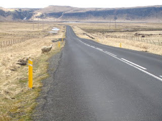
| Sheep crossing! |
 |
| Skeiðarársandur |
 |
| Skeiðarársandur |
 |
| One of the tongues of Vatnajökull, the largest glacier outside of the arctic regions |
 |
| A different tongue of Vatnajökull |


